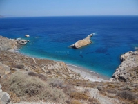
Beginning of the path that heads south from the beach of Agali to Fira Beach (with the characteristic mark FI). The trail runs along the coastline (and high above it) for 400 meters to Fira Beach, and from there it climbs for 1,200 meters to reach the main road from Chora to Ano Meria, near the three windmills.

Path to Fira Beach
Attributes
| Altitude (in meters) | : | 29 |
| Distance | : | 400 meters |
| Water | : | Island |
| Duration of Visit | : | 25 minutes |
| Difficulty | : | |
| Style | : |
More
Similar: Routes
DISTANCES


