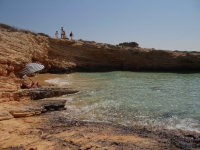
From the point where we descended to Nero Beach, the path continues south to the Cape of Pezoulia (or Kavo ton Pezoulion), and at some point the trail disappears. We can follow an imaginary peripheral track around the cape with the destination (for this part of our tour of the island) of Pezoulia Beach (total distance of about 1,600 meters). Alternatively, we can go straight from Nero to Pezoulia, walking about 500 meters. Around the middle of the cape, where the trail climbs steeply, we can look with awe at a deserted beach 50 meters below us, between the steep cliffs and accessible only by sea. From this point we start moving northwest, and in less than 600 meters we will see the very beautiful long beach of Pezoulia (with small pebbles and sand), on our left in the distance. To get to the beach, we need to descend a relatively steep 200 meter path--and of course to climb it on the way back. (Consider what this means!) We'll also need to walk another 400 meters to return to Nero Beac
Pezoulia
Attributes
| Altitude (in meters) | : | 0 |
| Type of Place | : | |
| Depth | : | |
| Type of Seabed | : | |
| Type of Beach | : | |
| Organized | : | No |
| Nudity | : | YesNo |
| Access | : | |
| Accessible | : |
More
Similar: Beaches
DISTANCES


